adsterra

Ibb


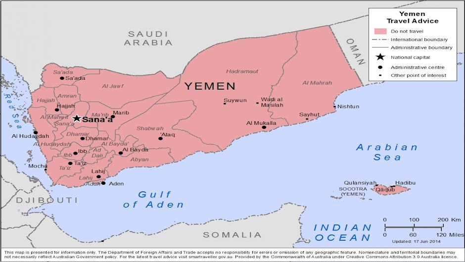
The city of Ibb is built on the mountain of Jabal Ba’adan, overlooking the lush green countryside of the rain-blessed governorate of the same name. The city likely was founded during the reign of the Himyarite Kingdom, when it was known as Thogha. The first historical document referring to the city of Ibb dates from the 10th century AD.
Throughout most of its history, Ibb had sat on the caravan route from Aden to Sana’a as well as pilgrimage route to Yemen, ensuring that it was never lacking in customers while maintaining its position as a trade centre.
The Old city of Ibb makes for a pleasant stroll. Most of the roads cannot be navigated by cars, giving it a distinctly different feel from the rest of the city. The houses are built differently from those of other Yemeni cities by their use of stone blocks.
Much of the woodwork you will see on the older doors was done by the population of Jewish artisans who lived in the city before 1948. There is a number of historically important buildings in the Old City, some of which date back before the advent of Islam such as al-Bayada reputed to have been built for a air-skinned Himyarite princess.
There are several important mosques in the old city. The Old Mosque was built during the reign of the second Muslim caliph, “Omar ibn al-Khatab.” The more aesthetically appealing mosque and red-brick minaret of al-Jalaliyya dates to the 18th-century Ottoman occupation.
Outside the Old City, the small tourist facility on top of Jabal Rabi (the mountain of My Lord) offers panoramic views of the city and surrounding countryside.
The fortress of Husn al-Habb (fortress of Grain sits on the mountain of Jabal Ba’dan). It is inaccessible by car, but a 30-minute to one-hour walk on the path leads up to the ruined remains. Surrounded by three walls and a sharp cliff face, Husn al-Habb was noted by the medieval Yemeni historians as being one of the strongest fortresses in the country.

Jiblah
The town of Jiblah is a small, quiet village tucked away between two wadis that is dominated by its larger neighbour, Ibb- only 8km away. In the past, Jiblah was the seat of power of one of Yemen’s greatest and most fondly remembered rulers. Queen Sayyida Arwa bint Ahmed ruled most of Yemen from the town during one of the country’s most brilliant periods.
In the 11th century the future Queen Arwa was born in the Haraz mountains as Sayyida bint Ahmed while “Ali ibn Sulayhi, her uncle and future fathe-in-law, had conquered and ruled most of Yemen. Arwa was educated within the royal palace at Sana’a under the tutelage of “Ali al-Sulayhi’s wife, Queen Asma.
Queen Arwa moved the state capital from Sana’a to Jiblah sometime after she assumed control in 1063. When she made the move, Jiblah was a small city that had been built 25 years prior – only slightly older than Arwa herself. The town was named after a Jewish potter who may have still been working there when Arwa transferred her seat of authority.
Arwa’s choice in Jiblah reflected the style of her rule well. Arwa was known to rule for the most part by wit and diplomacy. Queen Arwa was concerned with public works, trade, and religion.
It is very interesting, of course, to see the fond attachment Yemenis have to Queen Arwa- for a woman who ruled by diplomacy, she is revered as one of the greatest Yemeni leaders by conflict-prone, male-oriented Yemenis.
The historian Omarah wrote that Queen Arwa was: “perfect in beauty, of a clear-sounding voice, well read and skilful writer, her memory stored with history, with poetry, and with the chronology of past times”. Ask a Yemeni about her today- you will probably get a similar response.
The tomb of Queen Arwa is situated near the northern wall of the Queen Arwa Mosque. There are two minarets- the one by the southwest corner dates back to the construction of the mosque, although there have been several renovations since then. In the courtyard of the Mosque the visitor will be able to peer through the windows into the prayer hall.
One should, also, visit Sheikh Yakub Mosque (the mosque of Jacob). The villagers claim that this mosque is the oldest one in Jiblah, having existed as the town’s sole mosque before Arwa arrived and transformed the old palace into the grander mosque bearing her name.
Below the Sheikh Yakub Mosque, in the lower part of the town, there are several stone-arched bridges, one of which is said to date back to the time of Queen Arwa.
Hof protected natural Sorceress


Hof is a protected natural skilled in the province of Yemen, at a distance of almost 1400 kilometers from the capital Sana'a on the mountainous area of more than30,000 hectares ofthehighest elevation of about 1,400 meters above sea level, and Hof

محمية حوف الطبيعية الساحره " في اليمن السعيد "-2.jpglocated along the southern coast along the estimated 60 km of the mountain top Frk . characterized by a forest Hof contents of natural plant 
s where currently located many plant varieties are - according to preliminary surveys - 23 & 43 family vegetable plant species

In view of the nature and unique mountain climate, it is surrounded by forest-based environmental seasonal dry after the rainy season. Hof is the only forest of its kind in Yemen, it is also a forest nearby Dhofar in the Sultanate of Oman are considered Algabtan only of their kind in the Arabian Peninsula. Hof is also a forest is home to many rare and endangered species of plants and animals
Described as the forests of Hof and Dhofar they center of biodiversity and that they blur oasis in the Arabian Peninsula dry


Marib


In ancient times Marib, 120 km from Sana’a in the Wadi Adhana region, was a major centre of the Sabaean empire, the oldest, most celebrated and powerful of the south Arabian kingdoms. Ultimately it became the capital of the kingdom, supplanting Sirwah, 35km to the west. This once was Marib. As many inscriptions tell us, great temples and palaces once graced the city.
The fame of the once thriving metropolis survived. As late as the 10th century AD the Yemeni geographer and historian al-Hamdani described with nostalgia how Saba’s splendor and power vanished, and he paid tribute to the glories of the ruler’s palace Salhin in Marib. Inscriptions from the 7th century BC onward mention Salhin, and they also refer to two other palaces.
The city wall and the city gates:
Few traces of ancient buildings can be recognized at first glance within Marib’s partly visible ancient city wall. More than seven gates through the city wall allowed access to the city from different directions.
The defensive structure contains towers and curtain walls at regular intervals. Inscriptions and diverse building materials such as limestone, tuff and mud bear witness to extensive building activities at the fortifications, where construction and modification can be substantiated at least from the 8th through the 2nd centuries BC.
The Pillared temple:
The ruins of a mighty temple are preserved at the base of Marib’s “citadel”. The eight pillars that formed the propylon at the entrance of the temple, and several smaller pillars that presumably lined a courtyard, are still visible. A reconstruction of the temple suggests that it was similar in form to the Bar’an Temple in Marib’s southern oasis.
The Mosque:
Marib’s new Arab inhabitants built the mosque, in the 11th century AD or earlier, upon the remains of this mighty Sabaean temple. The Sulayman in Dawud Mosque is composed of two rectangular parts; a hall supported by columns, the haram, and prominent forecourt.
The two sections were separated from each other by the pillars of the Sabaean temple. In the northern wall of the haram is the prayer niche called the mihrab. The mosque is entirely built of stones taken from the sabaean city.
The city mound with mud houses:
Marib’s more “modern” mud houses that stand on the city hill are almost all uninhabited today. These buildings are about 200 years old, and are fine examples of the traditional residential architecture of the Marib region.
These rectangular structures rise to a height of four or five stories and stand on a stone foundation. A few of these buildings can still be entered through narrow and steep stairways. The view of the ancient city is wonderful.
Ancient Temple platform:
Numerous inscriptions indicated the existence of sanctuaries dedicated to different Sabaean gods within the city, in addition to the main temple. Only one of these structures, near the south-western city gate, retains traces of the locations of the pillars and walls.

Mukha


In the 17th and 18th centuries Mukha was famous as the center for exporting coffee grown in the Yemeni highlands (the coffee being given the name Mocha in the west). It was once a sprightly, whitewashed, cosmopolitan city spreading around a crescent-shaped bay, with superb buildings, palaces, mosques, coffee-houses, open squares and caravanserais capable of accommodating vast camel trains.
Before the 17th century sources are scarce.The anonymous Greek seafarer who wrote the Periplus of the Erythrean Sea, probably around AD100, describes the trade between Egypt and India and mentions the region of "Mouza" and of course Mukha is mentioned by the tenth-century Yemeni historian Al-Hamdani.
Visiting the port in 1616 on the Nassau, a senior Dutch merchant, Pieter van den Broecke, wrote that the "famous trading city is adorned with mosques and beautiful houses" and by 1618 the Dutch and British East India companies have set up permanent "factories" or trading stations there. The French, Belgians and Danes) and ultimately, the Americans) followed, as coffee drinking began to spread, and gold and silver poured into the city in payment for the exports.
Dominating the centre of the harbour front was an impressive governor's palace flanked by the Great Friday Mosque (still seen today) with its imposing minaret used by sailors as a navigation mark as they made for harbour. Beside the central jetty were a weighing house, a toll-house for the payment of import-export duties and warehouses. Also, there were large numbers of flat-roofed merchants' and administrators' houses built of stone and brick, as well as, smaller rectangular mud-and –reed houses of Tihama style strung out around the bay on the outskirts of town.

Socotra


Socotra is the largest in a small archipelago of four islands which include The Brothers (Samhah and Darsa) and Abd al Kuri. It lies in the Indian
Ocean on
a mid-oceanic volcanic ridge 500km roughly 130km long and 35km wide. Its name may be derived from the Arabic suqs qutra, means (the market of dragon’s blood”- a reference to the resin of its most famous tree species, or from a Sanscrit term for the “abode of the blest”.
Positioned near the southern gateway to the Red Sea, Socotra has been famous since ancient times. By the time of Abraham, traders from Egypt, Africa, India and Arabia called in here.
Ancient Egypt knew Socotra as the Island of the Genie- The spirit of the sacred tree, whose gum they used for mummification, temple offerings and medicine. In the first century AD the Greeks called Socotra, Dioscoridea. The Hadramout kingdom traded here out of Qana, near present-day Bir Ali, and later the Himyarites sailed here from Muza on the Red Sea.
The island’s population has now reached 100.000. The people speak the unique Socotri language.
Due to the island’s isolation and the fact that human activity has been kept to a minimum, about 30 per cent of its flora is unique to the archipelago. Domestic animals – camels, assess, goats, sheep and cats – were brought in by traders, but a natural balance has been reached and is preserved by the management of livestock to prevent overgrazing.
There are traditional restrictions on felling live trees. The vegetation is of great interest to botanists. Over 815 species of plant have now been recorded, and around 250 exist nowhere else in the world. There are seven species of frankincense tree on the island. This comprises one of the richest island floras in the world. Socotra has been described as the “Galapagos of the Arabian peninsula”.
The coastal plains tend to be fairly arid and vegetation is sparse. The foothills of the mountains display a shrubby landscape with incense trees and bizarre bottle-trunked trees. The species for which the island is renowned in evergreen woodland over the centre and east of the island and is the dominant tree in some areas.
The island is, also, one of the most important homes for rare birds in the Middle East, with over a hundred species of which seven are endemic. Around the coasts are large numbers of dolphins and some whales, in particular sperm whales.

Shibam - Seiyun - Tarim

ضبط كامل


S
hibam
The old walled city of Shibam is named after king Shibam Bin Harith Ibn Saba who ruled from here. It was a major city on the overland spice and incense route.
Although its origins are still not completely understood, it was trading at the time of the Sabaeans around the fourth and fifth centuries BC. The present settlement seems to have been established around the third century AD, after the destruction of Shabwa
It has been the commercial and political capital of Hadramout, many times. More recently, it was the commercial capital Wadi Hadramout until 1940, when an airport was built east of Seiyun, and the economic centre of gravity moved there.
Shibam is made up of domestic, commercial, educational, administrative and religious buildings – a small walled city that is a complete unit in itself. It has seven mosques, including the Rashid Mosque (sometimes called the Masjid al-Jum'a, the Fiday mosque), which date back to the early tenth century. Its unique architectural heritage of 500 mud-brick houses is an extraordinary example of traditional Yemeni building skills. Some of these houses are many centuries old and rise up to seven or eight storeys, the tallest reaching 30m.
The city's towering appearance prompted Freya Stark to describe it as "the Manhattan of the desert". It results partly from the fact that it is built on a mound made up of the remains of earlier towns.
The impression is enhanced by the abundance of windows, usually open, with wooden shutters, or harem grilles, and ventilation openings – often two at different levels on each floor; and by the long lines of shadows cast by the corners and edges of buildings in the afternoon sun. the city was added to UNESCO's World Heritage list in 1982.
Those who can afford it limewash their houses to protect them against termites and against the rains and flooding which occur from time to time in sa'il, the bed of the main wadi.
In general the windowless lower floors are used for grain storage, with areas for domestic use above and those for family and leisure above that. The main room on the second floor is used by men for socializing. It often has wonderful carved plasterwork and freestanding decorated wooden columns supporting the ceiling, while women's areas are found higher, usually on the third or fourth floor. The highest rooms are for communal use by the whole family, and on the upper levels there are often bridges (mi'bar) and doors connecting the houses. These are a defensive feature, but also a practical one – especially for old people who find it difficult to walk up and down the interminable staircases.
Seiyun:
Seiyun is the largest town of the Wadi Hdramout and the provincial capital and main government, commercial and communications centre. It is known for the fabulous palm groves that surround it and for its old market where traditional crafts such as jewellery are still practiced.
The town, which has a history going back thousands of years, probably owes its origin to this market, once and important stopping place on the early trade route that ran east through Wadi Masila and on to Shihr on the coast. Over many years the gathering of people here led to an urban centre being developed with houses, mosques and schools.
In 1494 there was an influx of people of the Hamdani tribes from north of Sana'a. Their leader was Amir Badr Ibn Tawariq Kathiri, the ancestor of the Kathiri Sultans who ruled from their capital here from 1516 until independence from the British in 1967.
The massive Sultan's Palace, with its four corner towers, stands in the oldest part of Seiyun, nest to the busy market; it is the largest mud-brick building in the Wadi Hadramout and an outstanding example of mud architecture. It was built in 1873, rebuilt in 1926 by Mansur bin Ghalib al Kathiri and whitewashed by his son Ali in 1935. Today it houses a museum of archaeology with finds from Raybun, one of Yemen's most important ancient sites as well as exhibits on popular traditions, folklore and costumes. It also includes objects from the colonial days.
Tarim:
Encircled by palm groves, is Tarim, which takes its name from a local king, Tarim Ibn Hadramout Ibn Saba Al-Assgar. It was a major centre for the Kathiri state until the 1960s; it was the capital of Hadhramout in ancient times and has been the religious capital of the Wadi Hadramout since the tenth century. Its history, like Shibam's, is related to the rise of the Himyar Kingdom and the destruction of Shabwa.
Tarim's reputation as a centre of religious teaching extended well beyond the Arabian Peninsula, reaching east Africa and Southeast Asia. Locals will tell you that there was once a mosque for each day of the Islamic year. (This was mainly due to the building of mosques by returned merchants as an offering of thanks for the wealth and business prosperity they had won in south – east Asia).

One of the most impressive, with its south-east Asian influences and 50-ft-high minaret, is the Al Muhdhar mosque. Built in 1915, it is one of the great symbols of Yemeni architecture. Tarim is also known for its libraries, the most famous being the Al Kaf Manuscripts Library, which houses around 5000 manuscripts from the surrounding region covering religion, the thoughts of the prophets, Islamic law, Sufism, medicine, astronomy, agriculture, biography, history, and mathematics. Many go back hundreds of years, and often contain vibrantly colored illuminations and illustrations.
The architecture of Tarim is more varied than that of any other Hadramout town. The town's building boom began in the nineteenth century and reached its height between the late 1920s and the early 1940s.

Al - Hodeidah


Al - Hodeidah is the Cinderella of the Red Sea and its captivating bride. It is one of the most beautiful cities of Yemen. It is the most diverse and most beautiful one between them. Its nature exhibits a wonderful dress of greenness and beauty round the year.
Its exhibited dress is perfumed with the fragrance of Jasmine, the redolence of screw pine and the scent of musk. Its climate is affected by all conditions and takes different phenomena along its coastal, mountainous and desert area.
Al - Hodeidah is the Yemen's fourth city in population terms and it developed as the leading port of the Ottomans when the coffee trade at Mukha dwindled and still retains its old Turkish quarter.
At night the markets light up, with men selling fruit under hurricane lamps, and in the early morning the fish market is a hive of activity.
Wealthy merchant families have opulent houses constructed in the Old Turkish area of Al - Hodeidah.
These buildings have lavishly decorated plasterwork interiors and superbly carved balconies. Upstairs, decorative stucco work and niches in walls pressed with colored glass and mirrors scintillate with painted peacock designs – a recurring theme throughout the Tihama and indication of the Indian influences seen in the region as a consequence of sea-tread.

Mukalla

Across the Jaul to the south of the Wadi Hadramout lie the Gulf of Aden and its two main historic ports of Mukkalla and Shihr.
Hans Helfritz, in the 1930s, wrote of "Mukkalla, a city of glistening whiteness, of extraordinary beauty, with its countless palaces and lofty towers, lies in a delightful bya close under the dark cliffs of the Jebel el Kara. It is the gateway to the province of Hadramout." Crammed between one of Yemen's great volcanic mountain regions and the sea, it is approached either by the coast road from Aden or from Seiyun in the Wadi Hadramout. This road passes through a succession of wadis and interesting towns and crosses the Jaul, a semi-desert mountain plateau.
Mukalla has been of great importance for many centuries, with its trade extending to India and Southeast Asia as the many Indian influences in its architecture show.
Locals will tell you that the town was founded in 1625 by a Yafa'I sultan, Ahmed bin Madyam al Kasadi. In 1914 it took over from Shihr, some 50km to the east, as capital of the Hadramout when the Qu'aitis ( originally a tribe of the Yafa) transferred their capital.
The town's architecture makes considerable creative use of gypsum and, in general, is distinctive for its Southeast Asian overtones and Indian inspiration, the latter evident everywhere in the narrow back streets where intricately carved doors and magnificent window screens can be found. The nightly illuminated ar-Rawdha and 'Umar mosques are delightful.
(The traveler Jorgen Bisch writes in his book Behind the Veil of Arabia that the doors are so important around Mikalla that at times the door is erected first, and the house is then built around it.)
The Sultan's Palace, which sits on the edge of the beach next to the town, was built in the late 1920s by Sultan 'Umar bn Awadh sl-Qu'aiti and draws on the Indian and new-classical style.

Taiz

Capital of Yemen during one of the country’s most brilliant periods, Taiz enjoys a position today as a major economic center. Taiz is first mentioned in the late 12th century AD during the reign of the Ayyubids – the forces which had first been led by Saladin’s brother Turanshah. At that time, the quarterly revenue of the port city of Aden was brought to Taiz.
The following are some tourist sites in Taiz worth to be visited :
The Old City of Taiz has two entrances – Bab al- Kabeer (the Great Gate) and Baba Musa (the Gate of Moses). The walled-in section of the town contains a lovely souk that specializes in a delicious kind of Taiz cheese, dried fish and silver jewellery.
Cairo Castle is the large fortification is currently being renovated using river stones and original building techniques.
Al-Ashrafiyyah Mosque is one of the few mosques in Yemen that tourists are permitted to enter. Tourist will be able to walk around the grounds and see the tombs of al-Ashrafa, his wife, his father, his sons, and his primary security guard as well as take one step into the mosque proper to admire the decorative work.
The tomb markings signify the location of the actual graves in rooms below. There are many lovely reliefs inside.
A secret door was found in 2005 leading to an underground room. Supposedly, many of the local governmental officials flocked here when the rumors got out in the hope of unearthing large treasures that might be stored within. But no treasures were found – only the tombs.
Al –Mu’tabiyya Mosque was built by a-Ashrafa in honour of his wife 23 years after the construction of his mosque. Both mosques were built with similar design, although the al-Mu’tabiyya is filled with designs and inscriptions. There are no tombs. The mosque used to be reserved for women to pray, but eventually the men decided they did not have enough space, and took it for themselves.
Abd al-Hadi Mosque was built in 1618 in commemoration of a Sufi saint of the same name who had died a hundred years earlier. There is a large grave monument to al-Hadi inside the structure.
Modhafer Mosque is the oldest mosque in Taiz, built by and named after the great-grandfather of al-Ashrafa. It has a minaret with two, large white domes.
Jabal Saber tops out at over 3..m. the villages dotting the mountainside are best known for their women, skilled bargainers who wear bright baltos and who are famed for their beauty.

*(source: Baradt Guide – Yemen)


Aden


Aden is one of the most beautiful coastal cities in Yemen, known for its wonderful beaches, old buildings, impregnable castles and many souks. It is, also, the economic capital of Yemen, 170 kilometers east of Bab-el-Mandeb.
Aden's ancient, natural harbour lies in the crater of an extinct volcano which now forms a peninsula, joined to the mainland by a low isthmus. This harbour, Front Bay, was first used by the ancient Kingdom of Awsan between the 5th and 7th centuries BC. The modern harbour is on the other side of the peninsula.
Aden has a number of historical and natural sites of interest to visitors. These include:
The Cisterns of Tawila - an ancient, water-cachement system located in the sub-center of Crater.
Sira Fort
The Aden Minaret
The Palace of the Sultanate of Lahej/National Museum
The Aden Military Museum
The Rimbaud House
The fortifications of Jebal Hadid and Jebal Shamsan
The beaches of Aden and Little Aden
Al-Aidaroos Mosque
The Zoroastrian Temple
The historical British churches

Reservoirs of Aden (The Tawila Tanks):
The Tanks in Crater are the oldest, construction in Aden, named after the gorge that cuts through the rocks beneath the eastern end of Jabel Shamsan. They are made up a series of 18 cisterns carved out of solid rock, actually a volcanic trachyte, and dammed in places to take advantage of the underlying rock pattern. They were originally built to give some stability in water supply in an area where several years often pass without serious rainfall. They in size and depth, but capture and collect rain falling in the surrounding mountains. Their capacity is an estimated 90 million liters. Tanks are connected by a series of small aqueducts with the overflow from one tank passing to the next in chain, transporting water right into the heart of Crater. They are believed to have been constructed while the control of Aden was in the hands of the Himyarites, sometimes around the first century AD.
But, since a port with the stature of Aden in ancient days would have needed an adequate amount of fresh water, it is possible that they existed before then in Sabaean times.

Sana'a


With Jebel Nugum towering over it, Sana'a sits on the narrowest point of a major mountain plateau, (2.286 metres) above sea level. The region's volcanic origin and regular rainfall make it fertile and it enjoys a temperate climate throughout the year with the occasional sharp frost in the small hours of winter nights. One legend tells of its founding by Shem the son of Noah.
Sana'a has been of great importance since ancient times, an urban centre for the tribes and its market always a trading nucleus for the region. It lies at the intersection to two major ancient trade routes, one of them linking the fertile upland plains, the other Marib and the Red Sea, and was a natural commercial centre. The name Sana'a probably derives from a South Arabian term meaning well fortified. Its Qasr as-Silha, rebuilt on the establishment of Islam, can be seen today with many of its walls still standing.
In the Old City of Sana'a around 14.000 tower houses rise up six (sometimes even nine) storeys high. Many originally had an agricultural vocation limited to adjacent land. The traditional social structures of Yemen partly define the way a house is built.
The technique of building combines skill handed down by one generation to another – to produce a creativeness in the use of space and light. While in many other Arab nations houses surround a secluded courtyard and look inwards, Yemeni houses look out on to communal streets.
So what of this ancient city of Sana’a? Visitors, Arab and European, have always been impressed by its fortifications, architecture, and gardens, and by its populousness- around twelve thousand in the early seventeenth century, up to forty thousand in the mid nineteenth century and around one million today. “Abounding in good things”, wrote the twelfth century Arab geographer al-Idrisi, “and full of buildings… the oldest, the largest and most populous city of Yemen” – of Arabia, he could have added – “an even atmosphere, a fertile soil, and the heat and the cold there are always temperate”.
Sana’a is basically a medieval creation, and many of the houses pre-date the nineteenth century, especially in their lower storeys. The organization of the city is typical of the region: massive perimeter walls, a large and thriving market, a Great Mosque for the larger congregation on Fridays, and a ruler’s palace, now long gone but likely in the earlier period to have been near the Great Mosque. Such a palace typically included administrative offices, reception salons, baths and well-watered gardens with more fountains.
To walk in the old city is an intense pleasure at any hour o the day.